
Click HERE for a high resolution JPG of the Montana Dark Sky Destinations Map. (Open, then right-click to save.)
Montana is blessed with millions of acres of public lands, thousands of stars over our “Big Sky Country,” and numerous public campgrounds where you can spend quality time with our awe-inspiring night skies. Here we have mapped a selection of 50 public campgrounds (that you can drive to!) and 10 dark sky event centers spread across our six “Visit Montana” regions. Create your own Dark Sky Trail by linking favorite campgrounds together,
or combine campgrounds, star parties and public observatories to create a Montana Dark Sky Vacation! Campgrounds are designated with numbers, dark sky event centers are designated with letters, and everything is linked to a website providing detailed information. Don’t forget to pack your bug and bear sprays, and it’s always a good idea to contact the managing agencies first for up-to-date status and road reports.

Night sky quality

Glacier Country includes the forested mountains and valleys of western Montana. It is home to our only officially designated dark sky area (so far), the Waterton-Glacier International Dark Sky Park. But the darkest areas are actually located in the northwestern and southwestern corners, in the Yaak Valley (#2 Pete Creek Campground) and Bitterroot National Forest (#8 Painted Rocks State Park), respectively.
Event centers in this region include the Dusty Star Observatory (A) and Apgar Visitors’ Center (B) in Glacier National Park, with both locations offering dark sky events during most summer nights. Near downtown Missoula, the University of Montana’s Star Gazing Room (C) is an intimate, 30-seat planetarium offering regularly scheduled shows throughout the year. The University also owns the Blue Mountain Observatory (D), where public star parties are scheduled several times each summer.

Comet Wirtanen and an Earth-grazer meteor light up the night sky above Dusty Star Mountain, in the Waterton-Glacier International Dark Sky Park.
| # | Name | Bortle | Radiance | Elevation | Coordinates | Plus Code | Agency | Website |
| (2015) | (2019) | (feet) | ||||||
| 1 | Kintla Lake | 2 | 0.17 | 4,058′ | 48.93579, -114.34609 | WMP3+8G Wurtz Hill, Montana | NPS | https://www.visitmt.com/listings/general/national-park-campground/kintla-lake-and-campground.html |
| 2 | Pete Creek | 1 | 0.19 | 2,963′ | 48.83042, -115.76647 | R6JM+89 Yaak, Montana | USFS | https://www.fs.usda.gov/recarea/kootenai/recreation/recarea?recid=49919&actid=43 |
| 3 | Rocky Gorge | 2 | 0.16 | 2,493′ | 48.65178, -115.31119 | 85W6MM2Q+R7 | USFS | https://www.fs.usda.gov/recarea/kootenai/recarea/?recid=71212 |
| 4 | Howard Lake | 2 | 0.16 | 4,114′ | 48.10103, -115.53036 | 85W64F29+CW | USFS | https://www.fs.usda.gov/recarea/kootenai/recarea/?recid=66107 |
| 5 | Logan State Park | 2 | 0.28 | 3,333′ | 48.03194, -115.06707 | 2WMM+66 Happys Inn, Montana | MTFWP | http://stateparks.mt.gov/logan/ |
| 6 | Fishtrap Lake | 2 | 0.17 | 4,150′ | 47.86157, -115.20315 | 85V6VQ6W+HV | USFS | https://www.fs.usda.gov/recarea/lolo/recarea/?recid=10307 |
| 7 | Spotted Bear | 2 | 0.16 | 3,737′ | 47.92661, -113.52717 | 85V8WFGC+GX | USFS | https://www.fs.usda.gov/recarea/flathead/recarea/?recid=66838 |
| 8 | Painted Rocks SP | 1 | 0.21 | 4,744′ | 45.69724, -114.29469 | MMJX+G7 Alta, Montana | MTFWP | http://stateparks.mt.gov/painted-rocks/ |
| 9 | Spring Gulch | 2 | 0.34 | 4,380′ | 45.85847, -114.02272 | VX5G+FM Medicine Hot Springs, MT | USFS | https://www.recreation.gov/camping/campgrounds/232327 |
| A | Dusty Star Observatory | 2 | 0.74 | 4,501′ | 48.74732, -113.43903 | PHW6+W9 St Mary, Montana | GNP | https://www.nps.gov/glac/learn/nature/night-sky.htm |
| B | Apgar Visitors Center | 2 | 0.29 | 3,196′ | 48.52289, -113.98693 | G2F6+6H Apgar, Montana | GNP | https://www.nps.gov/glac/learn/nature/night-sky.htm |
| C | UM Star Gazing Room | 5 | 48.35 | 3,238′ | 46.85963, -113.98650 | V257+R9 Missoula, Montana | UM | https://hs.umt.edu/physics/outreach/ |
| D | Blue Mountain Observatory | 4 | 0.42 | 6,404 | 46.81486, -114.18074 | RR79+WP Lolo, Montana | UM | http://hs.umt.edu/physics/blue-mtn-observatory/default.php |

The Southwest Montana region includes two excellent dark sky areas. The southern end of the Bob Marshall Wilderness Complex is buffered by the adjacent Helena National Forest, which has campgrounds that are accessible with a high-clearance vehicle, including Monture Creek Campground (#10). The south end of this region features
campgrounds in the Beaverhead-Deerlodge National Forest. This area has star-filled night skies, and it includes a popular campground adjacent to the ghost town of Bannack State Park (#16). The Montana Learning Center (E) is this region’s event center. The Center offers public and private star parties and an “Explore the Universe” kid’s camp, among many other activities.

Zodiacal light, Andromeda and Milky Way over the Bob Marshall Wilderness Complex
| # | Name | Bortle | Radiance | Elevation | Coordinates | Plus Code | Agency | Website |
| (2015) | (2019) | (feet) | ||||||
| 10 | Monture Creek | 2 | 0.16 | 4,193′ | 47.12570, -113.14256 | 4VG4+3F Ovando, Montana | USFS | https://www.fs.usda.gov/recarea/lolo/recarea/?recid=10323 |
| 11 | Copper Creek | 2 | 0.19 | 5,322′ | 47.07798, -112.61913 | 85V939HJ+7F | USFS | https://www.fs.usda.gov/recarea/hlcnf/recarea/?recid=62849 |
| 12 | Browns Lake | 2 | 0.21 | 4,285′ | 46.95120, -113.01144 | XX2Q+GM Coughlin, Montana | MTFWP | https://myfwp.mt.gov/fishMT/fas/39754193 |
| 13 | Mussigbrod | 1 | 0.20 | 6,516′ | 45.79092, -113.61071 | 85Q8Q9QR+H4 | USFS | https://www.fs.usda.gov/recarea/bdnf/null/recarea/?recid=5687&actid=30 |
| 14 | May Creek | 1 | 0.15 | 6,401′ | 45.65070, -113.78270 | 85Q8M628+7Q | USFS | https://www.fs.usda.gov/recarea/bdnf/null/recarea/?recid=5685&actid=43 |
| 15 | Fourth of Juy | 2 | 0.13 | 6,398′ | 45.66247, -113.06454 | MW6P+X5 Wise River, Montana | USFS | https://www.fs.usda.gov/recarea/bdnf/recarea/?recid=5675 |
| 16 | Bannack State Park | 2 | 0.21 | 5,784′ | 45.16466, -113.00439 | 5X7W+X8 Bannack, Montana | MFWP | http://stateparks.mt.gov/bannack/ |
| 17 | Horse Prairie | 1 | 0.23 | 5,561′ | 44.98796, -112.88848 | X4Q6+7H Grayling, Montana | USBR | https://www.visitmt.com/listings/general/recreation-area-campground/horse-prairie-campground.html |
| 18 | East Creek | 1 | 0.18 | 7,054′ | 44.56366, -112.66071 | H87Q+CQ Lima, Montana | USFS | https://www.fs.usda.gov/recarea/bdnf/recarea/?recid=5663 |
| 19 | Cliff Point | 1 | 0.2 | 6,352′ | 44.79194, -111.56111 | QCVR+FP Cliff Lake, Montana | USFS | https://www.fs.usda.gov/recarea/bdnf/null/recarea/?recid=5705&actid=31 |
| E | Montana Learning Center | 3 | 2.33 | 3,855′ | 46.65494, -111.71731 | M74J+7C Canyon Ferry, Montana | MLC | http://montanalearning.org/astronomy/ |

Yellowstone Country is a smaller region just north of the famous park. It features many wooded campgrounds that are typically less crowded and quieter than those inside Yellowstone park. The area also includes lakes, streams and rivers to keep you busy during the daytime. Most of these campgrounds charge a small fee during peak season (Memorial Day-Labor Day) but are free during shoulder seasons.
The region’s event center dazzles the mind! The Museum of the Rockies is one of the top-rated natural history museums in the world. Located on the campus of Montana State University in Bozeman, the museum features amazing dinosaur exhibits, and MOR’s state-of-the-art Taylor Planetarium (F) offers 4K digital projection on a 40-foot dome. Multiple shows each day, seven days a week. Bozeman Parks & Recreation (G) also hosts dark sky events during the summer months.

Palisade Falls & Big Dipper
| # | Name | Bortle | Radiance | Elevation | Coordinates | Plus Code | Agency | Website |
| (2015) | (2019) | (feet) | ||||||
| 20 | Beaver Creek | 1 | 0.21 | 6,532′ | 44.85366, -111.37861 | 85PCVJ4G+C9 | USFS | https://www.fs.usda.gov/recarea/custergallatin/recarea/?recid=5577 |
| 21 | Timber Camp | 2 | 0.13 | 7,182′ | 45.09471, -110.60533 | 39VV+MQ Jardine, Montana | USFS | https://www.fs.usda.gov/recarea/custergallatin/recarea/?recid=5631 |
| 22 | Greenough Lake | 2 | 0.25 | 7,238′ | 45.05566, -109.41264 | 3H4P+CV Richel Lodge, Montana | USFS | https://www.fs.usda.gov/recarea/custergallatin/recarea/?recid=60825 |
| 23 | Emerald Lake | 1 | 0.25 | 6,325′ | 45.25479, -109.69949 | 773X+9V Alpine, Montana | USFS | https://www.fs.usda.gov/recarea/custergallatin/recarea/?recid=60863 |
| 24 | Chippy Park | 2 | 0.15 | 5,450′ | 45.43684, -110.19028 | CRP6+V9 Contact, Montana | USFS | https://www.fs.usda.gov/recarea/custergallatin/recarea/?recid=5585 |
| 25 | Halfmoon | 1 | 0.15 | 6,516′ | 46.04211, -110.23994 | 85RF2QR6+CP | USFS | https://www.fs.usda.gov/recarea/custergallatin/recarea/?recid=5595 |
| 26 | Shields River | 1 | 0.22 | 6,385′ | 46.18395, -110.40504 | 85RF5HMR+3Q | USFS | https://www.fs.usda.gov/recarea/custergallatin/recreation/recarea/?recid=5619 |
| F | Taylor Planetarium | 5 | 35.97 | 4,921′ | 45.65925, -111.04373 | MX54+F3 Bozeman, Montana | MOR | https://www.museumoftherockies.org/taylor-planetarium/current-shows-and-showtimes/ |
| G | Bozeman Parks & Rec | 5 | 23.24 | 4,715′ | 45.70129, -111.02821 | PX2C+FP Bozeman, Montana | BOZ | https://infocusastronomy.com/events |

The Central Montana region is a transition zone between the western mountains and forests into the eastern high plains. Campgrounds on the southern end, like Hay Canyon (#29), are beautifully forested. The western-most area also offers forested camp choices along the edge of the Bob Marshall Wilderness Complex. But the region is dominated by the Missouri River drainage that flows lazily across the windswept plains, west to east.
Coalbanks (#34), Judith Landing (#35) and James Kipp (#36) campgrounds are accessible by car and by boat, so they tend to stay busy during the summer floating season. Further up the Missouri River, the Lewis and Clark Interpretive Center (H) is an event center that is built into the hillside near where the Corps of Discovery had to portage their boats 18 miles! A different kind of discovery is offered in the parking lot during monthly star parties hosted by the Central Montana Astronomical Society. It’s a can’t-miss destination!
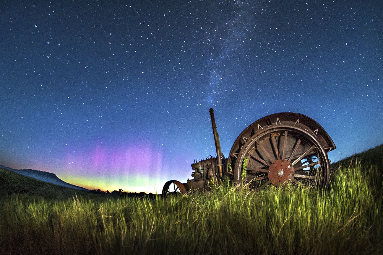
A rusting McCormick-Deering tractor watches northern lights dance on a prairie wind at dawn near Square Butte, east of Great Falls
| # | Name | Bortle | Radiance | Elevation | Coordinates | Plus Code | Agency | Website |
| (2015) | (2019) | (feet) | ||||||
| 27 | Forest Lake | 1 | 0.17 | 6,745′ | 46.24463, -110.43786 | 85RF6HV6+QX | USFS | https://www.fs.usda.gov/recarea/hlcnf/recarea/?recid=61478 |
| 28 | Whitetail Camp | 1 | 0.12 | 6,348′ | 46.68278, -110.50339 | 85RFMFJW+WP | USFS | https://www.fs.usda.gov/recarea/hlcnf/recarea/?recid=61470 |
| 29 | Hay Canyon | 1 | 0.20 | 5,302′ | 46.79877, -110.30015 | QMXX+HV Yogo Crossing, MT | USFS | https://www.fs.usda.gov/recarea/hlcnf/recarea/?recid=61532 |
| 30 | Crystal Lake | 2 | 0.17 | 6,086′ | 46.79336, -109.51075 | 85RGQFVQ+JH | USFS | https://www.fs.usda.gov/recarea/hlcnf/recreation/recarea/?recid=61526&actid=29 |
| 31 | Cave Mountain | 1 | 0.23 | 5,187′ | 47.89080, -112.72827 | 85V9V7RF+H6 | USFS | https://www.fs.usda.gov/recarea/hlcnf/recarea/?recid=61570 |
| 32 | West Fork | 1 | 0.22 | 5,623′ | 47.96089, -112.80680 | 85V9X56V+77 | USFS | https://www.fs.usda.gov/recarea/hlcnf/recarea/?recid=61562 |
| 33 | Island Area | 1 | 0.22 | 3,025′ | 48.33557, -111.14747 | 8VM5+R9 Tiber Dam Camp, MT | USBR | https://www.visitmt.com/listings/general/recreation-area-campground/island-area-campground.html |
| 34 | Coalbanks | 1 | 0.24 | 2,526′ | 48.03132, -110.23649 | 2QJ7+RM Coal Banks Landing, MT | BLM | https://www.blm.gov/visit/coal-banks-landing |
| 35 | Judith Landing | 1 | 0.26 | 2,411′ | 47.74036, -109.62861 | 85VGP9RC+2W | BLM | https://www.blm.gov/visit/judith-landing |
| 36 | James Kipp | 1 | 0.27 | 2,290′ | 47.62773, -108.68469 | 85VHJ8G4+XJ | BLM | https://www.blm.gov/visit/james-kipp-recreation-area |
| H | Lewis&Clark Interpretive Center | 5 | 16.9 | 3,228′ | 47.52957, -111.23552 | GQH7+QQ Great Falls, Montana | USFS | http://www.lewisandclarkfoundation.org/events.php |

The Missouri River Country region holds some of Montana’s darkest skies, and some of our most light-polluted skies (from oil and gas development). This is the land of picturesque, abandoned homesteads, vast tracts of range land, and isolated patches of native shortgrass prairie. The Big Muddy flows through its heart into Fort Peck Reservoir. In this country, a sudden rain squall transforms the
two-tracks into truck-swallowing gumbo. Avoid the backroads during rainy weather or you might find yourself watching the stars for a couple of nights in a row until the road dries out enough for you to escape. In 2019 the American Prairie Reserve built a new campground at Antelope Creek (I) that serves as the region’s dark sky event center. Star parties are offered there during summer months by the ‘Space Naturalists’ from In Focus Astronomy, out of Bozeman.

The summer Milky Way floats above aN ENDANGERED black-footed ferret at U.L. Bend National Wildlife Refuge
| # | Name | Bortle | Radiance | Elevation | Coordinates | Plus Code | Agency | Website |
| (2015) | (2019) | (feet) | ||||||
| 37 | Nelson Reservoir | 2 | 0.20 | 2,231′ | 48.49405, -107.52819 | FFR9+RG Sleeping Buffalo, MT | USBR | https://www.visitmt.com/listings/general/recreation-area-campground/nelson-reservoir.html |
| 38 | Brush Lake State Park | 3 | 0.33 | 2,011′ | 48.60456, -104.10254 | JV2R+74 Dagmar, Montana | MTFWP | http://stateparks.mt.gov/brush-lake/ |
| 39 | Rock Creek | 1 | 0.25 | 2,313′ | 47.76603, -106.28802 | 85VMPPMR+HV | MTFWP | https://www.visitmt.com/listings/general/fishing-access-site/rock-creek-fishing-access-site.html |
| 40 | Hell Creek State Park | 1 | 0.50 | 2,264′ | 47.61719, -106.88774 | 85VMJ487+M7 | MTFWP | http://stateparks.mt.gov/hell-creek/ |
| 41 | Buffalo Camp | 1 | 0.20 | 2,310′ | 47.76315, -107.77464 | Q67G+66 Sun Prairie, Montana | APR | https://www.americanprairie.org/buffalo-camp |
| 42 | Fourchette Creek | 1 | 0.17 | 2,267′ | 47.66885, -107.66985 | M8CP+79 Dryer Place, Montana | ACE | https://www.visitmt.com/listings/general/a-c-e-campground/fourchette-bay-campground.html |
| 43 | Crooked Creek | 1 | 0.20 | 2,260′ | 47.43187, -107.93689 | 85VJC3J6+JR | ACE | https://centralmontana.com/listings/17944.htm |
| I | Antelope Creek Campground | 1 | 0.17 | 2,917′ | 47.71399, -108.71820 | P7GM+V2 Dy Junction, Montana | APR | https://www.americanprairie.org/project/antelope-creek-mars-vista |

Hidden pockets of chalky bluffs and forested hills rise above Southeast Montana’s range lands and prairies. There isn’t much public land here, but the region features more than enough hidden treasures to create your own dark sky adventures. Tucked away in the southwestern corner, Barry’s Landing Campground (#45) lies at the end of
the (paved) road in the Bighorn Canyon National Recreation Area — desert country that surprises even the few native Montanans who find it. Further east, the Carter County Museum ( J ) in Ekalaka keeps busy as one of Montana’s most popular event locations. In addition to the annual Dino Shindig, the Museum also hosts summer star parties, children’s activities and many other dark sky events.

Northern lights ripple over Bighorn Canyon and Lake in Southeast Montana
| # | Name | Bortle | Radiance | Elevation | Coordinates | Plus Code | Agency | Website |
| (2015) | (2019) | (feet) | ||||||
| 44 | Timber Creek Dispersed | 1 | 0.19 | 5,800′ | 46.72586, -109.48438 | 85RGPGG7+5W | USFS | https://www.fs.usda.gov/recarea/hlcnf/recreation/recarea/?recid=61474&actid=29 |
| 45 | Barry’s Landing | 2 | 0.15 | 3,734′ | 45.09603, -108.21000 | 4Q3G+4G Hillsboro, Montana | BLM | https://www.visitmt.com/listings/general/national-park-campground/barry-s-landing.html |
| 46 | Red Shale | 2 | 0.25 | 3,202 | 45.57085, -106.14670 | HV92+MM Willow Crossing, MT | USFS | https://www.fs.usda.gov/recarea/custergallatin/recreation/camping-cabins/recarea/?recid=60853&actid=29 |
| 47 | Holiday Spring | 1 | 0.22 | 4,055′ | 45.63818, -105.97487 | J2QG+C8 Stacey, Montana | USFS | https://www.fs.usda.gov/recarea/custergallatin/recarea/?recid=60851 |
| 48 | Lantis Spring | 1 | 0.23 | 3,901′ | 45.63052, -104.17688 | 85QQJRJF+95 | USFS | https://www.fs.usda.gov/recarea/custergallatin/recarea/?recid=60841 |
| 49 | MacNab Pond | 1 | 0.26 | 3,461′ | 45.83575, -104.43223 | RHM8+XF Ekalaka, Montana | USFS | https://www.fs.usda.gov/recarea/custergallatin/recarea/?recid=60849 |
| 50 | Medicine Rocks SP | 2 | 0.19 | 3,425′ | 46.04177, -104.47099 | 85RQ2GRH+MM | MTFWP | http://stateparks.mt.gov/medicine-rocks/ |
| J | Carter County Museum | 13.19 | 3,422′ | 45.89102, -104.54657 | VFR3+9C Ekalaka, Montana | CCM | https://www.cartercountymuseum.org/ |
These base maps are from Dark Sky Map, showing night sky brightness from “The New World Atlas of Artificial Sky Brightness” (2015). Light pollution has continued to increase since these values were calculated in 2015.
Bortle scale and night sky radiance calculations from Light Pollution Map, which is also based on the “The New World Atlas of Artificial Sky Brightness” but regularly updated with VIIRS satellite data. The Bortle Scale indicates night sky brightness from 1 (excellent dark-sky site) to 9 (inner-city sky). Radiance numbers indicate the zenith sky brightness, reported here in magnitude/arc second squared.
Latitude/longitude coordinates and Plus Codes are two methods of identifying locations on a map.
Agencies and Entities: American Prarie Reserve (APR), Army Corps of Engineers (ACE), Bozeman Parks & Recreation (BOZ), Bureau of Land Management (BLM), Carter County Museum (CCM), Glacier National Park (GNP), Montana Fish Wildlife & Parks (MTFWP), Montana Learning Center (MLC), Museum of the Rockies (MOR), National Park Service (NPS), University of Montana (UM), Bureau of Reclamation (USBR), U.S. Forest Service (USFS)